|
|
|
Digital Products
M&O are official Sub-distributors for a wide range of digital
products.
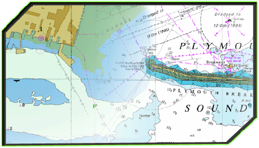
ARCS - Admiralty Raster Chart Service
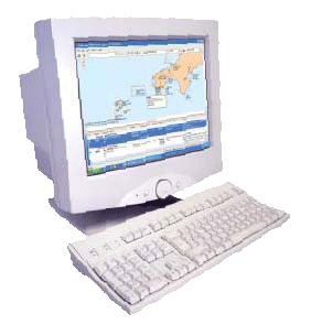
ARCS Navigator
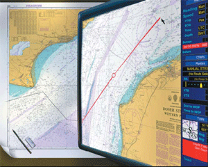 ARCS
Navigator is the world's leading electronic raster chart service
from the United Kingdom Hydrographic Office (UKHO) and is now used
by the giants of the commercial shipping world. ARCS
Navigator is the world's leading electronic raster chart service
from the United Kingdom Hydrographic Office (UKHO) and is now used
by the giants of the commercial shipping world.
ARCS charts are digital facsimile
copies of the
world famous Admiralty paper charts and are supplied on CD-ROM. ARCS
charts use the same high quality images as Admiralty paper charts,
making the progression from traditional chart table to ECS and ECDIS
an easy, logical step.
Extensive, official coverage of the world's commercial shipping
routes, main ports and harbours is provided by over 3000 ARCS charts
with weekly updates available on CD-ROM, keeping charts fully in
line with Admiralty Notice to Mariners
ARCS Navigator is available on annual subscription. Coverage is
licenced on a chart by chart basis, meaning that users pay only for
the charts they require. Instant access to additional charts can be
quickly and easily obtained in emergency situations via phone, fax
or e-mail.
Benefits of
ARCS
ARCS can provide all the benefits of
real time
navigation.
Improved Safety -
When
integrated with GPS, the vessel's position, course and speed can be
measured with a greater accuracy than by using traditional methods
and thereby greatly reduces the risk of grounding.
Improved
Situational Awareness -
When used in
conjunction with radar, ARCS charts can show the actual distance and
direction of other vessels and obstructions, which is invaluable in
particularly busy areas.
Ease of Updating
-
ARCS
Navigator benefits from a fully automated update service where
corrections are issued electronically on CD - ROM each week. The
updates keep your ARCS charts fully up to date with the latest
safety-critical information and are quick and easy to apply.
Time Saving -
Route
planning is simplified as plans can be constructed quickly and
efficiently in advance and stored for future use.
ENCs - (Electronic Navigation Charts) - Vector charts for ECDIS
 Electronic
Navigational Charts (ENC) are official vector charts that conform to
the IHO's S57 Version Product Standard and can only be issued by a
national hydrographic authority. ENCs are the only vector charts
that may be used for primary navigation in place of paper charts
when used in conjunction with a type approved Electronic Chart
Display Information System (ECDIS) and supported by a suitable
back-up system. Electronic
Navigational Charts (ENC) are official vector charts that conform to
the IHO's S57 Version Product Standard and can only be issued by a
national hydrographic authority. ENCs are the only vector charts
that may be used for primary navigation in place of paper charts
when used in conjunction with a type approved Electronic Chart
Display Information System (ECDIS) and supported by a suitable
back-up system.
TotalTide
Admiralty TotalTide is the world's most comprehensive tidal
prediction program providing official tidal height and tidal stream
predictions. The data is presented clearly and concisely both in
graphical and tabular format and covers over 7000 of the worlds main
ports. TotalTide provides accurate tidal prediction data by using a
powerful calculation algorithm together with official tidal data
from the world's premier hydrographic authorities.
Admiralty Digital List of Lights and Fog Signals (ADLL)
The Admiralty Digital List of
Lights (ADLL) is the world's most advanced source of light and fog
signals information. ADLL provides quick, efficient and accurate
data updates. The programme provides worldwide coverage on one CD of
over 70,000 unique light structures.
ADLL uses the same official data as that provided in the paper
version and has been designed to meet the SOLAS carriage
requirements.
Updating
ADLL is sold fully
up to date at time of purchase and includes an automated weekly
update service as part of the subscription price. Amendments are
supplied electronically on CD-ROM every week enabling updates to be
completed in seconds, greatly reducing the time and effort that has
traditionally been spent manually correcting the paper volumes,
whilst minimising the risk of error.
Remote Updating
Updates are
also available via e-mail or from a simple to use page on the
following link
http:/updates.ukho.gov.uk/adll/
, which enables users to access the most up to date
information as soon as it becomes available.
Admiralty Notice to Mariners Online
The Admiralty
Notices to Mariners Online service enables mariners to download NTMs
directly from the following website,
http://www.ukho.gov.uk/amd/weeklyNms.asp
IMO Digital Publications
IMO’s
publishing activities provide to the world maritime community the
numerous texts (conventions, codes, regulations, recommendations,
guidelines, etc.) prepared by the Organization. To increase the
world-wide dissemination and promotion of this information, the
Organization launched a list of electronic publications and virtual
publications available from their website as well as an internet
subscription service featuring key products.
Chartco - Global Satellite Data Services
The ChartCo system provides bulk
data delivery directly to ships by satellite using the ships
existing Inmarsat A, B or Fleet 77 terminal together with a
dedicated ChartCo receiver. All information is received
automatically without any interference with the ship's normal
communications. The ChartCo service includes: -
ChartManager
-
Update and management of paper
charts and publications including Notices to Mariners (NMs) and
correction tracings for both BA and US charts.
OceanXpress -
Update service for
electronic charts and publications.
MetManager -
Weather information. |